Cebrenia quadrangle
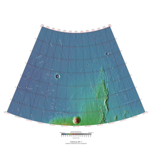
The Cebrenia quadrangle is one of a series of 30 quadrangle maps of Mars used by the United States Geological Survey (USGS) Astrogeology Research Program . The quadrangle is located in the northeastern portion of Mars’ eastern hemisphere and covers 120° to 180° east longitude (180° to 240° west longitude) and 30° to 65° north latitude. The quadrangle uses a Lambert conformal conic projection at a nominal scale of 1:5,000,000 (1:5M). The Cebrenia quadrangle is also referred to as MC-7 (Mars Chart-7). [1] It includes part of Utopia Planitia and Arcadia Planitia . The southern and northern borders of the Cebrenia quadrangle are approximately 3,065 km (1,905 mi) and 1,500 km (930 mi) wide, respectively. The north to south distance is about 2,050 km (1,270 mi) (slightly less than the length of Greenland). [2] The quadrangle covers an approximate area of 4.9 million square km, or a little over 3% of Mars’ surface area. [3]
Page Revisions
| Year | Metadata | Sections | Top Words | First Paragraph |
| 2018 |
190787 characters 21 sections 86 paragraphs 77 images 326 internal links 33 external links |
3. Results from Viking II mission |
hiwish 0.398 hirise 0.338 hecates 0.257 program 0.220 tholus 0.174 soil 0.170 galaxias 0.158 hrad 0.148 cebrenia 0.144 mie 0.139 chaos 0.120 crater 0.119 ice 0.113 ejecta 0.110 pedestal 0.110 |
The Cebrenia quadrangle is one of a series of 30 quadrangle maps of Mars used by the United States Geological Survey (USGS) Astrogeology Research Program . The quadrangle is located in the northeastern portion of Mars’ eastern hemisphere and covers 120° to 180° east longitude (180° to 240° west longitude) and 30° to 65° north latitude. The quadrangle uses a Lambert conformal conic projection at a nominal scale of 1:5,000,000 (1:5M). The Cebrenia quadrangle is also referred to as MC-7 (Mars Chart-7). [1] It includes part of Utopia Planitia and Arcadia Planitia . The southern and northern borders of the Cebrenia quadrangle are approximately 3,065 km (1,905 mi) and 1,500 km (930 mi) wide, respectively. The north to south distance is about 2,050 km (1,270 mi) (slightly less than the length of Greenland). [2] The quadrangle covers an approximate area of 4.9 million square km, or a little over 3% of Mars’ surface area. [3] |
| 2017 |
179931 characters 20 sections 74 paragraphs 65 images 326 internal links 33 external links |
3. Results from Viking II mission |
hiwish 0.319 hirise 0.288 hecates 0.285 tholus 0.193 soil 0.188 program 0.180 galaxias 0.175 hrad 0.164 cebrenia 0.160 mie 0.154 chaos 0.133 pedestal 0.121 ice 0.113 ejecta 0.110 crater 0.110 |
The Cebrenia quadrangle is one of a series of 30 quadrangle maps of Mars used by the United States Geological Survey (USGS) Astrogeology Research Program . The quadrangle is located in the northeastern portion of Mars’ eastern hemisphere and covers 120° to 180° east longitude (180° to 240° west longitude) and 30° to 65° north latitude. The quadrangle uses a Lambert conformal conic projection at a nominal scale of 1:5,000,000 (1:5M). The Cebrenia quadrangle is also referred to as MC-7 (Mars Chart-7). [1] It includes part of Utopia Planitia and Arcadia Planitia . The southern and northern borders of the Cebrenia quadrangle are approximately 3,065 km (1,905 mi) and 1,500 km (930 mi) wide, respectively. The north to south distance is about 2,050 km (1,270 mi) (slightly less than the length of Greenland). [2] The quadrangle covers an approximate area of 4.9 million square km, or a little over 3% of Mars’ surface area. [3] |
| 2016 |
155998 characters 18 sections 56 paragraphs 51 images 318 internal links 26 external links |
3. Results from Viking II mission |
hecates 0.328 hirise 0.224 tholus 0.222 soil 0.217 galaxias 0.202 hiwish 0.190 cebrenia 0.184 mie 0.178 chaos 0.154 ice 0.131 hrad 0.126 viking 0.114 perchlorate 0.114 program 0.114 lava 0.107 |
The Cebrenia quadrangle is one of a series of 30 quadrangle maps of Mars used by the United States Geological Survey (USGS) Astrogeology Research Program . The quadrangle is located in the northeastern portion of Mars’ eastern hemisphere and covers 120° to 180° east longitude (180° to 240° west longitude) and 30° to 65° north latitude. The quadrangle uses a Lambert conformal conic projection at a nominal scale of 1:5,000,000 (1:5M). The Cebrenia quadrangle is also referred to as MC-7 (Mars Chart-7). [1] It includes part of Utopia Planitia and Arcadia Planitia . The southern and northern borders of the Cebrenia quadrangle are approximately 3,065 km (1,905 mi) and 1,500 km (930 mi) wide, respectively. The north to south distance is about 2,050 km (1,270 mi) (slightly less than the length of Greenland). [2] The quadrangle covers an approximate area of 4.9 million square km, or a little over 3% of Mars’ surface area. [3] |
| 2015 |
144691 characters 16 sections 51 paragraphs 45 images 292 internal links 26 external links |
3. Results from Viking II mission |
hecates 0.337 tholus 0.228 soil 0.223 galaxias 0.207 hirise 0.196 mie 0.183 cebrenia 0.166 chaos 0.158 hiwish 0.143 ice 0.134 hrad 0.130 viking 0.117 perchlorate 0.117 lava 0.110 magnetite 0.109 |
The Cebrenia quadrangle is one of a series of 30 quadrangle maps of Mars used by the United States Geological Survey (USGS) Astrogeology Research Program . The quadrangle is located in the northeastern portion of Mars’ eastern hemisphere and covers 120° to 180° east longitude (180° to 240° west longitude) and 30° to 65° north latitude. The quadrangle uses a Lambert conformal conic projection at a nominal scale of 1:5,000,000 (1:5M). The Cebrenia quadrangle is also referred to as MC-7 (Mars Chart-7). [1] It includes part of Utopia Planitia and Arcadia Planitia . The southern and northern borders of the Cebrenia quadrangle are approximately 3,065 km (1,905 mi) and 1,500 km (930 mi) wide, respectively. The north to south distance is about 2,050 km (1,270 mi) (slightly less than the length of Greenland). [2] The quadrangle covers an approximate area of 4.9 million square km, or a little over 3% of Mars’ surface area. [3] |
| 2014 |
131002 characters 14 sections 45 paragraphs 42 images 286 internal links 26 external links |
3. Results from Viking II mission |
hecates 0.352 tholus 0.239 soil 0.233 galaxias 0.217 hirise 0.214 cebrenia 0.173 chaos 0.165 hiwish 0.164 hrad 0.136 mie 0.127 perchlorate 0.122 ice 0.118 lava 0.115 magnetite 0.114 vbf 0.111 |
The Cebrenia quadrangle is one of a series of 30 quadrangle maps of Mars used by the United States Geological Survey (USGS) Astrogeology Research Program . The quadrangle is located in the northeastern portion of Mars’ eastern hemisphere and covers 120° to 180° east longitude (180° to 240° west longitude) and 30° to 65° north latitude. The quadrangle uses a Lambert conformal conic projection at a nominal scale of 1:5,000,000 (1:5M). The Cebrenia quadrangle is also referred to as MC-7 (Mars Chart-7). [1] The southern and northern borders of the Cebrenia quadrangle are approximately 3,065 km (1,905 mi) and 1,500 km (930 mi) wide, respectively. The north to south distance is about 2,050 km (1,270 mi) (slightly less than the length of Greenland). [2] The quadrangle covers an approximate area of 4.9 million square km, or a little over 3% of Mars’ surface area. [3] |
| 2013 |
129174 characters 14 sections 45 paragraphs 42 images 286 internal links 25 external links |
3. Results From Viking II Mission |
hecates 0.355 soil 0.235 tholus 0.219 galaxias 0.218 hirise 0.216 cebrenia 0.174 chaos 0.166 hiwish 0.165 hrad 0.137 mie 0.128 perchlorate 0.123 ice 0.119 lava 0.115 magnetite 0.115 vbf 0.112 |
The Cebrenia quadrangle is one of a series of 30 quadrangle maps of Mars used by the United States Geological Survey (USGS) Astrogeology Research Program . The quadrangle is located in the northeastern portion of Mars’ eastern hemisphere and covers 120° to 180° east longitude (180° to 240° west longitude) and 30° to 65° north latitude. The quadrangle uses a Lambert conformal conic projection at a nominal scale of 1:5,000,000 (1:5M). The Cebrenia quadrangle is also referred to as MC-7 (Mars Chart-7). [1] The southern and northern borders of the Cebrenia quadrangle are approximately 3,065 km (1,905 mi) and 1,500 km (930 mi) wide, respectively. The north to south distance is about 2,050 km (1,270 mi) (slightly less than the length of Greenland). [2] The quadrangle covers an approximate area of 4.9 million square km, or a little over 3% of Mars’ surface area. [3] |
| 2012 |
127193 characters 14 sections 47 paragraphs 40 images 287 internal links 25 external links |
3. Results From Viking II Mission |
hecates 0.353 soil 0.234 tholus 0.218 galaxias 0.218 hirise 0.215 cebrenia 0.174 chaos 0.166 hiwish 0.164 hrad 0.136 ice 0.134 mie 0.128 perchlorate 0.123 lava 0.115 magnetite 0.114 vbf 0.111 |
The Cebrenia quadrangle is one of a series of 30 quadrangle maps of Mars used by the United States Geological Survey (USGS) Astrogeology Research Program . The quadrangle is located in the northeastern portion of Mars’ eastern hemisphere and covers 120° to 180° east longitude (180° to 240° west longitude) and 30° to 65° north latitude. The quadrangle uses a Lambert conformal conic projection at a nominal scale of 1:5,000,000 (1:5M). The Cebrenia quadrangle is also referred to as MC-7 (Mars Chart-7). [1] |
| 2011 |
63269 characters 14 sections 36 paragraphs 25 images 141 internal links 12 external links |
3. Results From Viking II Mission |
hecates 0.342 soil 0.294 cebrenia 0.219 tholus 0.192 hrad 0.171 mie 0.161 hirise 0.158 perchlorate 0.154 magnetite 0.144 ice 0.140 viking 0.138 chemicals 0.124 galaxias 0.117 organic 0.111 phlegra 0.110 |
The Cebrenia quadrangle is one of a series of 30 quadrangle maps of Mars used by the United States Geological Survey (USGS) Astrogeology Research Program . The quadrangle is located in the northeastern portion of Mars’ eastern hemisphere and covers 120° to 180° east longitude (180° to 240° west longitude) and 30° to 65° north latitude. The quadrangle uses a Lambert conformal conic projection at a nominal scale of 1:5,000,000 (1:5M). The Cebrenia quadrangle is also referred to as MC-7 (Mars Chart-7). [1] |
| 2010 |
58654 characters 14 sections 34 paragraphs 25 images 136 internal links 11 external links |
3. Results From Viking II Mission |
hecates 0.348 soil 0.299 cebrenia 0.222 tholus 0.195 hrad 0.174 mie 0.163 perchlorate 0.157 hirise 0.149 magnetite 0.146 viking 0.140 ice 0.133 chemicals 0.126 galaxias 0.119 organic 0.113 phlegra 0.112 |
The Cebrenia quadrangle is one of a series of 30 quadrangle maps of Mars used by the United States Geological Survey (USGS) Astrogeology Research Program . The quadrangle is located in the northeastern portion of Mars’ eastern hemisphere and covers 120° to 180° east longitude (180° to 240° west longitude) and 30° to 65° north latitude. The quadrangle uses a Lambert conformal conic projection at a nominal scale of 1:5,000,000 (1:5M). The Cebrenia quadrangle is also referred to as MC-7 (Mars Chart-7). [1] |
| 2009 |
50570 characters 11 sections 28 paragraphs 18 images 127 internal links 9 external links |
hecates 0.377 soil 0.307 cebrenia 0.241 tholus 0.211 hrad 0.189 mie 0.177 magnetite 0.159 ice 0.144 chemicals 0.137 phlegra 0.121 hirise 0.112 apsus 0.110 buvinda 0.110 magnesium 0.102 sulfur 0.099 |
The Cebrenia quadrangle is one of a series of 30 quadrangle maps of Mars used by the United States Geological Survey (USGS) Astrogeology Research Program . The quadrangle is located in the northeastern portion of Mars’ eastern hemisphere and covers 120° to 180° east longitude (180° to 240° west longitude) and 30° to 65° north latitude. The quadrangle uses a Lambert conformal conic projection at a nominal scale of 1:5,000,000 (1:5M). The Cebrenia quadrangle is also referred to as MC-7 (Mars Chart-7). [1] |